Thursday, December 4, 2008

Etymological Map of the World


Thanks to Andrea Berez for pointing out this map of the world, which shows place names in their "original" or "literal" form. Unfortunately, none of the screen shots shows Alaska, but they provide some ideas for what might be possible with Alaskan place names.

Sunday, September 21, 2008

Canadian Languages Map


Online interactive mapping can be a great way to convey information about language information. I stumbled upon the Atlas of Canada site the other day. It presents language info by community, as well as language vitality by community, both on clickable interactive images.

Aboriginal languages by community
Aboriginal languages by ability

Friday, March 14, 2008

Early Krauss papers

I was digging around in the Alaska Native Language Archive this week and happened to run across some earlier work on language mapping by Michael Krauss. One of my favorites is a 1963 unpublished manuscript entitled Classification of the Athapaskan Languages. The first line of the paper begins:
    "Classification of the dialects within Athapaskan continues to present insuperable problems."
There is clear acknowledgment of the difficulty of resolving competing evidence for defining language boundaries. That is, the location of a language boundaries depends very much on the choice of criteria for defining that boundary.
    "The Alaskan situation ... is best described by isoglosses which sometimes cross, and by bundles of isoglosses, parts of which veer off to cross sometimes with other isoglosses. Even a classification of all the Alaskan dialects into languages is arbitrary to a large extent, and as such is only a terminological expedient."
In the Archive there are also several folders containing early versions of isogloss maps, presaging the 1974 Map. For example, the map below shows the isogloss in Western Alaska for the Proto-Athabaskan sound *ts, which has five different pronunciations in the modern languages ([tθ], [tS], [ts], [tł], [tš]). Notice that there are no language names on this map! Indeed, the boundaries don't necessarily represent languages--just different pronunciations of *ts.


Some interesting things are already apparent on this early map. Krauss groups the first three sounds together because although they sound slightly different, they function similarly within the language. So one can ask why Region 1 has been separated into two parts, a southwest zone and a northeast zone. As it turns on, the little piece of Region 2 which extends down to meet Region 3 represents a relatively recent migration into the Toklat-Bearpaw area. Thus, linguistics--even in this raw form--has something to tell us about history.

If this sort of thing seems useful to our exploration of the history of the Map, I can work to scan and post more of these early papers and maps.

Friday, February 22, 2008

Interviewing Dr. Krauss


On Tuesday, February 19th, I had the opportunity to sit down with Dr. Michael Krauss at his home in Fairbanks, AK to have a conversation about the Alaska Native Peoples and Languages map. Having flown up from Anchorage for only the day, I returned with nearly five hours in audio recordings. Together with ANLC's Gary Holton, ISER staff assembled a list of questions that center on Dr. Krauss' early motivators for making the map and the methodologies that he employed in doing so. Having himself never written down the processes or challenges that he faced in creating the map, Dr. Krauss was incredibly cooperative and we are thankful to him for volunteering his time.

ISER plans on transcribing the interview and then publishing it on Alaskool with audio excerpts. We are also interested in publishing a summary of the relevant information garnered from the interview in an explanatory booklet that would accompany the revised map, still in draft form.

Aside from describing his early interest in Alaska Native languages, Dr. Krauss also talked about the map's political undertones and the message that he hoped it would convey. He also spoke to the empowering qualities of Native languages, both literally and figuratively, and the decisions that Native people confronted with language loss inevitably have to make.

Below are a handful of the questions addressed in the interview:

  • What was your motivation for mapping languages in Alaska and Canada?
  • How did you measure the number of current speakers within any village, and how did those methodologies change from one village to the next?
  • In your view, how can Alaska Native communities most effectively revitalize their languages?
  • Why did you determine the boundaries between languages, especially in places where there are few communities?
  • The Map shows 20 languages, while previous maps showed fewer. Would a diffeerent number be equally plausible / possible?

Monday, February 11, 2008

BMEEC Conference and Questions

On January 30th, 2008, several members of the Institute of Social and Economic Research (ISER) and the Alaska Native Language Center (ANLC) presented at the 34th Annual Bilingual Multicultural Education Equity Conference held in Anchorage, AK.
The presentation was titled: "Alaska Native Languages and Peoples Map After 30 Years". The conference presentation, panel discussion and question/answer session allowed participants the opportunity to learn and discuss the issues surrounding the mapping of Native Peoples and Languages of Alaska. The Native Peoples and Languages of Alaska Map was compiled by Michael Krauss and the Alaska Native Language Center (ANLC) in 1974 and was revised in 1982. ISER and ANLC are working to revise the map in GIS technologies and with current data. The presentation discussed the revisions to the map, language names, numbers of speakers and other information that the map presents.
The following people served on the panel discussion:
Jim Kerr - ISER
Larry Kaplan - ANLC
Michael Krauss - Professor Emeritus, Map Author - UAF - ANLC
Gary Holton - ANLC
Colin West - ISER
Meghan Wilson - ISER
Tim Argetsinger - ISER
Joan Kane - First Alaskans Institute

We complied a list of questions that the audience members asked. They are listed as follows:

  • How much will a new map cost approximately?
  • Change Koyukon to Denaakk'e.
  • Is there/will there be a data graph or report that shows the status of language speakers using the information from these three maps? This type of report will be helpful to show leaders the status of our language to hopefully push the urgency to teach our languages in our schools, communities, etc...
  • Maybe put out a paper for emails to start a list serv for the project?
  • Is there a written history/documentation for the early ANLC map process?
  • Which year was the Osgood map published?
  • Is ANLC mainly documenting languages or do they push for fluency?
  • How do you define "speakers" of a Native Language?
  • Do you distinguish between active and passive speakers?
  • Will lower and middle Tanana be distinguished?
  • Was Cup'ik dropped?
  • Isn't there a difference for the Koyukon boundary based on Jim Kari's later work?
  • In counting the number of speakers, will students learning the language be counted?
  • What is the connection of Alaska-Athabascan and Navajo?
  • Is GIS a public/free program?

These questions were posted to let people from ISER and ANLC post answers and create a discussion based on what the audience wanted to know about the map and map revisions.

Tuesday, February 5, 2008

Map page on ANLC site

In anticipation of the need for additional explanatory material about the Map, I've begun to draft a web page on the ANLC site. This is still very much a draft, a work-in-progress, and I welcome comments. Perhaps something like this could serve as a point of departure for an eventual accompanying publication.

Past, Present, Future

Jim Kerr keeps reminding me of how well Michael Krauss' 1980 monograph, Alaska Native Languages: Past, Present, Future serves as a companion reference to the Map, but until I reread the text today I didn't realize how right Jim was. The appendices are a bit out of date, but the main text, based on lectures given by Krauss in Leningrad on May 29, 1979 and in Albuquerque on October 16, 1979, remains very relevant. I especially like the first sentence:

    Alaska is the homeland or birthplace, perhaps better the "cradle of civilization," of two great North American language families: the Eskimo-Aleut and the Na-Dene.

What wonderful imagery! The modern world tends to view Alaska as a backwater, existing on the edge of civilization (a situation exacerbated by the Iron Curtain and its lingering effects). But nothing could be further from the truth. Elsewhere Krauss has used the phrase "crossroads of continents," reflecting the fact that not only did Eskimo-Aleut and Na-Dene spread across Alaska to the far edges of North America, but presumably many of the other 50 or so indigenous language families of North and South America also once passed through Alaska. In a very real sense, all indigenous peoples of the Americas were once Native Alaskans. The linguistic history of Alaska's Native peoples is a rich and varied one.


A full-text pdf scan of Past, Present, Future can be downloaded from ERIC. I wonder if it would be worth trying to do OCR on this so that the text could be made available in searchable, indexed format online. This would also make it possible to add in little updates here and there.

Friday, February 1, 2008

Revising the Alaska Native Language Map

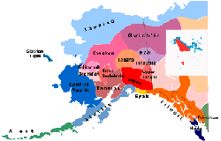
The most authoritative map of Alaska's Native languages is Michael Krauss' Native Peoples and Languages of Alaska, published in 1974 (revised 1982). This map delineates 20 different indigenous languages belonging to two main language families: Athabascan-Eyak-Tlingit and Eskimo-Aleut. Haida is a language isolate (not demonstrably related to any other languages), and Tsimshian is a member of the small Tsimshianic family.

The language boundaries were determined based on an exhaustive survey of language pronunciation by speakers from each Alaska Native village. In many cases distinguishing between languages can be difficult, as the linguistic criteria yield conflicting and overlapping results. The chosen boundaries represent a compromise based on established tradition and Krauss' linguistic intuition.

This blog is a forum to discuss proposed revisions to the Map and to help accumulate information about the history of the Map and the history of Native languages in Alaska.