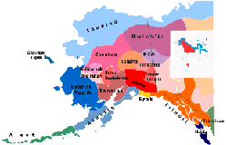
The presentation was titled: "Alaska Native Languages and Peoples Map After 30 Years". The conference presentation, panel discussion and question/answer session allowed participants the opportunity to learn and discuss the issues surrounding the mapping of Native Peoples and Languages of Alaska. The Native Peoples and Languages of Alaska Map was compiled by Michael Krauss and the Alaska Native Language Center (ANLC) in 1974 and was revised in 1982. ISER and ANLC are working to revise the map in GIS technologies and with current data. The presentation discussed the revisions to the map, language names, numbers of speakers and other information that the map presents.
The following people served on the panel discussion:
Jim Kerr - ISER
Larry Kaplan - ANLC
Michael Krauss - Professor Emeritus, Map Author - UAF - ANLC
Gary Holton - ANLC
Colin West - ISER
Meghan Wilson - ISER
Tim Argetsinger - ISER
Joan Kane - First Alaskans Institute
We complied a list of questions that the audience members asked. They are listed as follows:
- How much will a new map cost approximately?
- Change Koyukon to Denaakk'e.
- Is there/will there be a data graph or report that shows the status of language speakers using the information from these three maps? This type of report will be helpful to show leaders the status of our language to hopefully push the urgency to teach our languages in our schools, communities, etc...
- Maybe put out a paper for emails to start a list serv for the project?
- Is there a written history/documentation for the early ANLC map process?
- Which year was the Osgood map published?
- Is ANLC mainly documenting languages or do they push for fluency?
- How do you define "speakers" of a Native Language?
- Do you distinguish between active and passive speakers?
- Will lower and middle Tanana be distinguished?
- Was Cup'ik dropped?
- Isn't there a difference for the Koyukon boundary based on Jim Kari's later work?
- In counting the number of speakers, will students learning the language be counted?
- What is the connection of Alaska-Athabascan and Navajo?
- Is GIS a public/free program?
These questions were posted to let people from ISER and ANLC post answers and create a discussion based on what the audience wanted to know about the map and map revisions.

4 comments:
Osgood's map appeared in 1936 in a monograph entitled The Distribution of the Northern Athapaskan Indians, published by Yale University.
The decision to distinguish Middle Tanana (i.e., the language of the Salcha-Goodpaster band of Athabascans) basically boils down to a question of how to distinguish languages versus dialects. In choosing to include Salcha-Goodpaster as a dialect of (Lower) Tanana, as opposed to a separate language, Krauss was motivated in part by a desire to promote language survival. By including them as one language, only one writing system would be needed, and teaching materials developed for Minto and Nenana could be used in Salcha as well. I discuss this a bit more here.
The Koyukon boundary is discussed extensively by Michael Krauss' in the introduction to the Koyukon Athabaskan Dictionary. That article also provides a nice introduction to general issues of language mapping and how to distinguish between languages and dialects.
With respect to Middle Tanana: The last Salcha speaker was actually Eva Moffit, with whom I worked from 1991-1993, when she died. Eva was Bessie Barnabas' daughter.
There are several other inventory features besides the presence of retroflexes in Lower that distinguish Lower from Middle Tanana, and a number of lexical ones as well.
My understanding of the original map design was that the question of where to draw the line, or whether to draw a solid or a dashed line, depended as much on social determinations as it did on linguistic evidence. Time has passed, and social situations have changed more than the language data, especially for the languages that are no longer spoken. If we want to devise a new way to figure out how different two forms of Athabascan are from one another, based on linguistic evidence alone, I think it could be very interesting. However, perhaps we don't need to do that for this map.
As to the relationship between writing systems and language status on the map: For the most part, publications by ANLC have used an orthography for Minto-Nenana that works quite nicely for Salcha, Chena and Goodpaster as well. So ANLC has been consistent in maintaining Lower-Middle as a unit in this respect. ST
Post a Comment